Camelback Mountain
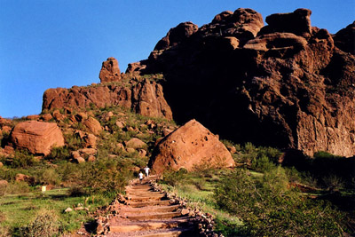
Camelback Mountain is definitely the most difficult hiking trail on this list for a few reasons. The biggest reason for its difficulty is because of how much elevation gain there is in such a short distance. The trail can also be pretty rocky, especially as you get to the top. Once you do finally make it to the top though the views are the best in the Phoenix-Metro area.
Directions: From E. Sky Harbor Blvd. follow signs for Downtown/I-10 W/AZ-51/Phoenix and merge onto I-10 W(1.5 miles). Then take exit 147A-B for AZ loop 202 E. (1 mile). Then take exit 4 for 52nd St. toard Van Buren St.(3 miles) Then you turn left onto 52nd St. and then turn right onto E. Thomas Rd. (2 miles). Then you turn left on 56th St. and make a slight left left onto E. Valle Vista Rd. and you will arrive at the park (2.5 miles).